Aram Dorsum
(Aram Dorsum is one of three candidate landing sites being studied for the ExoMars 2020 mission. The other sites are Mawrth Vallis and Oxia Planum. Hypanis Vallis was considered until 2015 - it was downselected at the Third Landing Site Selection Workshop.)
The candidate landing site at Aram Dorsum (7.9°N, 348.8°E) lies in the highlands of Arabia Terra, about 100 km north of Crommelin crater, in the Oxia Palus region. Of the short-listed sites, it is the highest and the closest to the Martian equator.
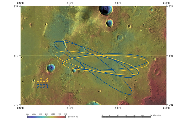 |
| ExoMars landing ellipses in Aram Dorsum. Credit: ESA/DLR/FU Berlin & NASA MGS MOLA Science Team |
Aram Dorsum is located on plains of middle Noachian age, about 4 billion years old, in a region that has been sculpted during two major aqueous periods. It comprises layered sedimentary rocks crossed by a prominent inverted channel ridge, which is 80 km long and 1.2 km wide. (The former channel now exists as a raised topographic feature.)
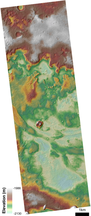 |
| Detail of region in Aram Dorsum. Credit: NASA/MRO/HiRISE/Aram Dorsum Team/LSSWG |
The Aram Dorsum inverted channel, which curves from north-east to west across the landing site, is part of an ancient alluvial landscape. Flow direction is inferred to be toward the west, based on the regional drainage patterns and on topographic maps.
The overlying materials that are present in the rest of the site appear to be a mixture of sedimentary deposits and suggest that the inverted channel system has been exhumed only relatively recently. Some parts of the terrain may have been exposed for as little as 100 million years.
It seems that extensive fluvial networks carved the plains during the Noachian period. A second, aqueous phase occurred more recently, resulting in outflow channels that eroded the plains before terminating in the Chryse basin.
Outside the landing ellipse (major-axis 104 km, minor-axis 19 km), Aram Dorsum originates at a plateau with no evident drainage network. It is unclear if the source region represents a former lake, or if the drainage basin is buried or has been removed by erosion.
The total relief is minimal, with a variation of less than 70 m. The stratigraphy within the landing ellipse includes thick remnant mesas, about 100 m high. The majority of the landing ellipse is covered by polygonally fractured terrain extending from either side of the inverted channel. This is thought to consist of marginal flood plain deposits, or alluvial sediments.
The available data do not show clear evidence of hydrated minerals, although they may be hidden by overlying dust. Some multispectral data suggest sporadic occurrences of phyllosilicates (chemically altered clay minerals) within the landing ellipse.
The geologic history of the site reveals sustained water activity during the planet’s early history, followed by burial (providing protection from radiation and oxidation for most of Mars’ geological history), and fairly recent exhumation – within the last 500 million years.
The ancient lakes and rivers at this site would have been favourable for the development of life, as well as for the preservation of its biosignatures. The long-lived aqueous conditions recorded in the migrating channel pattern would have been critical for establishing a habitable environment at the Aram Dorsum site.
There are few topographic obstacles or steep slopes, ensuring ready accessibility to sites of scientific interest, regardless of the exact landing location. However, there exists an area at the west (up-range) end of the ellipse pattern reaching –1900 m with slopes exceeding the prescribed thresholds.
Further details about the landing site selection process can be found in the report of the Landing Site Selection Working Group: Recommendation for the Narrowing of ExoMars 2018 Landing Sites.